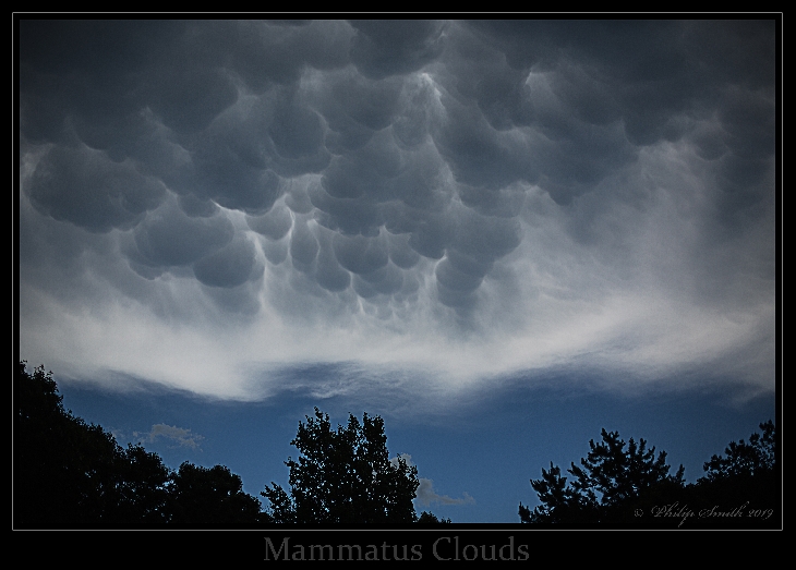
Come Before The Storm Mammatus Clouds
Taken by Philip Smith on June 30, 2019 @
Manorville, NY, USA
Click photo for larger image

| |
Camera Used: Canon Canon EOS 5D Mark III
Exposure Time: 1/8000
Aperture: f/2.0
ISO: 100
Date Taken: 2019:07:01 21:15:41
|
|
| More images
Details:
On 6-30-19 outside my backdoor were clouds I never saw before. My wife told me that she saw a weather warning alert on the tv for very bad fast moving weather for are area. After about 20 minutes later I took this picture. I did not know what kind of clouds I was seeing at the time. I now know that the clouds are " Mammatus " Mammatus clouds are pouch-like cloud structures and a rare example of clouds in sinking air. Sometimes very ominous in appearance, mammatus clouds are harmless and do not mean that a tornado is about to form; a commonly held misconception. In fact, mammatus are usually seen after the worst of a thunderstorm has passed. In this case we had over 60 mph winds for about 15 minutes. I named this image the "Come Before The Storm". This is more information to share with you. Characteristics. Mammatus are most often associated with anvil clouds and also severe thunderstorms. They often extend from the base of a cumulonimbus, but may also be found under altocumulus, altostratus, stratocumulus, and cirrus clouds, as well as volcanic ash clouds. The name mammatus is derived from the Latin mamma (meaning "udder" or "breast"). Kind Regards to All.
Photographer's website:
No URL provided.
|
|
|